Log in
All resources
Create a design
223 Free Artworks of Old Maps Of Landes
maps in the rijksmuseum amsterdam
bibliothèque nationale de france
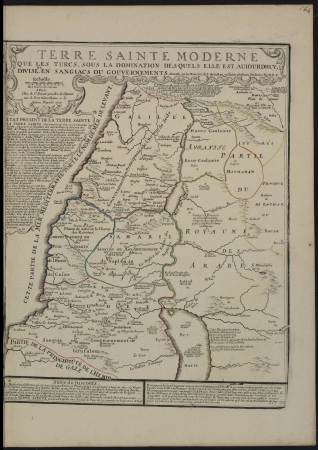
old maps of the holy land
old maps of haarlem
haarlemmerhout
prints of cartouches in the rijksmuseum amsterdam
prints by jan luyken in the rijksmuseum amsterdam
maps by jan luyken
jan luyken
maps in the library of congress
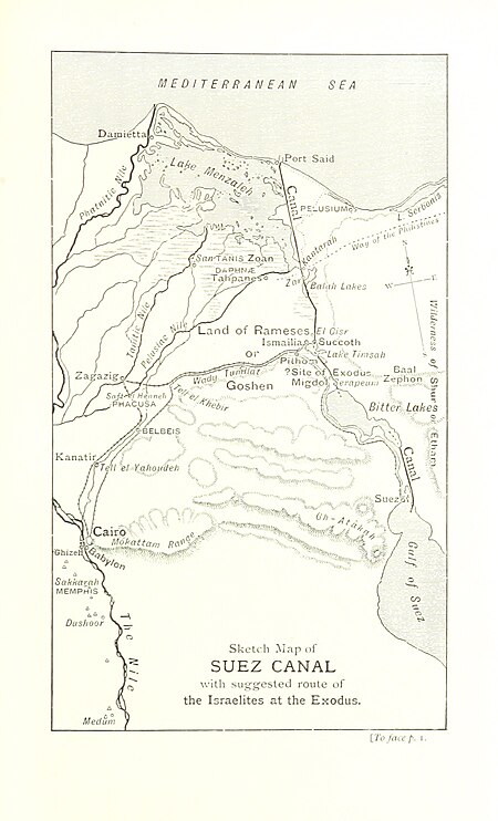
old maps of the sinai peninsula
1870s maps of palestine
1770s maps of alaska
robert de vaugondy
peru. incidents of travel and exploration in the land of the incas
yucay
atlas of the great elector
archipelagus orientalis
victor levasseur - maps of france
old maps of meurthe (department)
hamburgische elbkarte von melchior lorichs
parts of old maps of hamburg
maps of spain by tomas lopez
old maps of guadeloupe
johann david schleuen
old maps of prussia
old maps of the holy land
1866 maps
old maps of the holy land
1866 maps
old maps of the tribes of israel
old maps of ancient israel
1660s maps of spain
1667 maps
old maps of pyrénées-orientales
1852 maps of france
sanson maps of the holy land
old maps of canaan
nouvelle géographie universelle, vol. ix
old maps of haifa bay
sanson maps of the holy land
old maps of canaan
eran laor cartographic collection
alexis-hubert jaillot
life of christ (barberini tapestries)
old maps of the holy land
maps by johannes vingboons
old maps of south holland
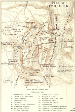
the land of the monuments (1896)
old maps of the suez canal
tower of babel in engravings
maps by nicolaes visscher i
maps by jakob van der schley
1753 maps
the land of the monuments (1896)
old maps of the suez canal
old maps of the holy land
thomas fuller (writer)
maps of spain by tomas lopez
1762 maps of spain
considérations géographiques et physiques sur les nouvelles découvertes au nord de la grande mer
1750s maps of the russian empire
maps from the earth and its inhabitants, vol. ix
old maps of the holy land
old maps of st. augustine, florida
john white (colonist and artist)
steendrukkerij p. blommers
old maps of kalimantan
old maps of north holland
zaandam
the british monarchy (1743)
maps in the british museum
1779 maps of new york (state)
old maps of new york (state)
in the forbidden land, an account of a journey into tibet (1909)
maps of the history of tibet
etchings in the national gallery of art (washington, d.c.)
niccolo nelli
eran laor cartographic collection
michel van lochom
maps in the amsterdam museum
1690s maps of palestine
old geological maps by jean-etienne guettard
jean étienne guettard
lawrence h. slaughter collection of english maps, charts, globes, books and atlases
maps by claude joseph sauthier
old maps of alexander the great's empire
gog and magog
19th-century maps of vaucluse
1852 maps of france
historical images of rhodes (city)
erhard reuwich
19th-century maps of maastricht
maps in hcl (maastricht)
old geological maps by jean-etienne guettard
jean étienne guettard
henri le roy (1579-)
diocese of aire
historical images of rhodes (city)
erhard reuwich
18th-century maps of antarctica
1741 maps
maps in the library of congress
1857 maps of pennsylvania
old maps of lazio
henry le roy
maps in the library of congress
old maps of hungary
considérations géographiques et physiques sur les nouvelles découvertes au nord de la grande mer
old maps of the yellow sea
1640s maps of greece
marco boschini
maps of the dutch east india company - south africa
1747 maps
maps from university of amsterdam special collections
atlas der neederlanden
maps from university of amsterdam special collections
atlas der neederlanden
historical images of rhodes (city)
erhard reuwich
maps by daniel stoopendaal
biblical maps
maps of ancient israel by philippe de la rué
old maps of the stations of the exodus
maps in the library of congress
1849 maps
1720s maps of palestine
nicolas de fer
maps by john cary
1801 maps
russo-turkish war (1877–1878) in art
great eastern crisis (1875–78)
old maps of lycoming county, pennsylvania
maps in the library of congress
old maps of salvador (bahia)
jacob van meurs
romanticism,neoclassicism
1852 maps of france
a system of modern geography (1810)
old maps of the holy land
a system of modern geography (1810)
old maps of the holy land
english-language maps of asia
maps by john cary
old maps of ancient israel
1720s maps of palestine
maps in the rijksmuseum amsterdam
old maps of the holy land
maps of the mexican-american war
maps by joseph warren revere
maps in the library of congress
1777 maps of north america
cádiz in the 18th century
old maps of cádiz
cádiz in the 18th century
old maps of cádiz
maps by joachim bormeester
1685 maps
prints by jan luyken in the rijksmuseum amsterdam
maps in the rijksmuseum amsterdam
maps of paris from the david rumsey historical map collection
maps of île-de-france by françois de la guillotière
maps of ancient israel by philippe de la rué
old maps of the stations of the exodus
prints by jan luyken in the rijksmuseum amsterdam
maps in the rijksmuseum amsterdam
maps in the rijksmuseum amsterdam
old maps of tholen
old maps of haarlem
haarlemmerhout
maps in the rijksmuseum amsterdam
old maps of suriname
haarlem in the 19th century
haarlemmerhout
old maps of haarlem
haarlemmerhout
old maps of haarlem
haarlemmerhout
1650s maps of the americas
1658 maps
prints by jan luyken in the rijksmuseum amsterdam
maps in the rijksmuseum amsterdam
1821 maps of the united states
maps by john cary
maps in the rijksmuseum amsterdam
old maps of brazil
1646 in haarlem
haarlemmerhout
1827 in haarlem
haarlemmerhout
maps in the rijksmuseum amsterdam
old maps of brielle
prints by jan luyken in the rijksmuseum amsterdam
maps in the rijksmuseum amsterdam
huis ter kleef in art
1867 in haarlem
old maps of haarlem
haarlemmerhout
nicolas sanson. “mappe-monde, ou carte generale du monde.”
1667 map of madagascar by guillaume sanson
nicolas sanson. “mappe-monde, ou carte generale du monde.”
map of the bosphorus strait by guillaume sanson (1665)
maps of paris from the david rumsey historical map collection
maps of paris by braun & hogenberg
prints by jan luyken in the rijksmuseum amsterdam
maps in the rijksmuseum amsterdam
prints by claes jansz. visscher (ii) in the rijksmuseum amsterdam
siege of breda 1624-1625
maps in the rijksmuseum amsterdam
old maps of germany
101 - 200 of 223
Next page
/ 3


![Sabinorum et Marsorum agri descriptio. 11; Typus utriusque Latii [...]. 8 / auctore Philippo Cluverio; H. Le Roy fecit, 1624](https://cdn.creazilla.com/illustrations/10001535937/sabinorum-et-marsorum-agri-descriptio-11-typus-utriusque-latii-8-auctore-philippo-cluverio-h-le-roy-fecit-1624-sm.webp)


![Map of the old new lands in West Voorn / I. Luiken fecit cum aqua forti; A. Steyaart invented; I. Stemmer's sculpsit, Romeyn de Hooghe, [1701]](https://cdn.creazilla.com/illustrations/10000299995/map-of-the-old-new-lands-in-west-voorn-i-luiken-fecit-cum-aqua-forti-a-steyaart-invented-i-stemmers-sculpsit-romeyn-de-hooghe-1701-md.jpg)
![Map of the Old Land of Diepen Dorst / I. Shutters fecit cum aqua forti; A. Steyaart invenit; I. Stemmers sculpt, Romeyn de Hooghe, [1701]](https://cdn.creazilla.com/illustrations/10001043124/map-of-the-old-land-of-diepen-dorst-i-shutters-fecit-cum-aqua-forti-a-steyaart-invenit-i-stemmers-sculpt-romeyn-de-hooghe-1701-md.jpg)